
 By neha - June 25, 2026
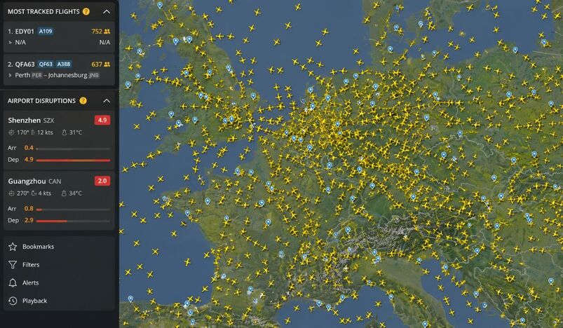
Open Flightradar24 right now and you see something remarkable. Europe is blanketed in aircraft. Hundreds of yellow plane icons fill the screen from the UK to Austria. The English Channel, France, the Netherlands, Germany, Belgium, and Luxembourg are all dense with air traffic. This is what peak aviation looks like in real time.
The screenshot captured at 08:02 UTC on June 25, 2026 tells a vivid story. The skies over Western and Central Europe are among the busiest on Earth at this moment.
What the Map Shows
The Flightradar24 live map is centered over the United Kingdom and Northwestern Europe. The density of aircraft is striking. The Netherlands and Belgium show some of the heaviest concentration of flights. Germany and France follow close behind.
The view confirms what aviation data has long shown. European airspace handles some of the world's highest traffic volumes. On a typical summer morning, thousands of flights operate simultaneously across this corridor.
The United Kingdom sits at the western edge of the frame. Air traffic becomes progressively denser moving east toward Germany. The skies over the Netherlands, Belgium, and Luxembourg are almost too crowded to count individual aircraft.
The Most Tracked Flights Right Now
Flightradar24 highlights two flights drawing the most attention from users worldwide at the time of capture.
The top spot belongs to EDY01, flight number A109, with 752 people tracking it live. The departure and destination show as N/A, meaning the aircraft is either not broadcasting full data or operates outside standard commercial routes. The A109 is a helicopter, which makes this a distinctly unusual entry at the top of the most-tracked list.
Second place goes to QFA63, Qantas flight QF63, operated on an Airbus A388. This flight runs from Perth to Johannesburg. It has 637 active trackers watching it at this moment. The QF63 is one of the most remarkable routes in commercial aviation. It is the only Airbus A380 service that operates entirely within the Southern Hemisphere.
The Perth to Johannesburg run covers over 11,000 kilometres and takes roughly 14 to 15 hours in the air.
Airport Disruptions Flagged in Asia
The disruption panel on the left side of the screen highlights two airports facing delays and disruptions right now.
Shenzhen Airport, airport code SZX, is reporting a disruption score of 4.9, which is significant. The airport is currently seeing winds at 170 degrees at 12 knots. The temperature is 31 degrees Celsius. The arrival disruption score stands at 0.4, suggesting departures are bearing the brunt of delays.
Guangzhou Baiyun International Airport, airport code CAN, is also flagged with a disruption score of 2.0. Wind conditions show 270 degrees at 4 knots. The temperature there is 34 degrees Celsius. The disruption score of 2.9 at departures signals meaningful delays for passengers flying out.
Both airports sit in China's Pearl River Delta region, one of the most aviation-intensive zones in all of Asia.
What Flightradar24 Actually Is
Flightradar24 started as a simple hobby project. Two Swedish founders put an antenna on a Stockholm rooftop and built a flight-tracking site that quickly outgrew every expectation. Today the platform operates the largest ADS-B receiver network in the world. It connects more than 40,000 receivers globally. It tracks over 200,000 flights every day. More than 4 million users visit the platform daily under normal conditions.
The platform collects data primarily through ADS-B signals that aircraft broadcast automatically. Volunteers around the world host receivers at their homes and businesses.
Those signals feed into the live map in near real time. The result is the closest thing aviation has to an all-seeing eye in the sky.
During the Middle East conflict earlier in 2026, Flightradar24 traffic surged to 20 million visits in a single day. Airlines rerouted flights rapidly as airspace over Iran, Iraq, and surrounding countries closed or became dangerous. The platform showed those changes happening live, flight by flight, in real time.
Why This View of Europe Matters
The European airspace shown in the screenshot represents the core of global connectivity. Flights crossing this corridor carry passengers between North America and Asia.
They connect Africa to Scandinavia. They link the Middle East to Western Europe.
The density of aircraft visible in this single frame reflects the enormous scale of modern commercial aviation. On a summer morning in June, with travel demand running near peak levels, European skies carry the weight of millions of journeys happening simultaneously.
Flightradar24 makes all of that visible in a single glance. Every yellow icon on the map is a real aircraft carrying real people. The image at 08:02 UTC captures just one fraction of one second in a system that never stops moving.

_03-27-2026_08-27.jpg)
.jpg)
.jpg)
.jpg)


.jpg)
.jpg)


.jpg)


.jpg)
.png)
.jpg)


Leave a comment